

Create thematic maps and integrate them into your R workflow.
This package helps you design different cartographic representations
such as proportional symbols, choropleths, or typology maps. It also
provides several functions for displaying layout elements that enhance
the graphical presentation of maps (e.g., scale bar, north arrow, title,
labels). mapsf maps sf objects on base graphics.
You can install the released version of mapsf from
CRAN with:
install.packages("mapsf")Alternatively, you can install the development version of mapsf (the
dev branch) from r-universe
with:
install.packages("mapsf", repos = c("https://riatelab.r-universe.dev", "https://cloud.r-project.org"))This is a basic example which shows how to create a map with mapsf.
library(mapsf)
# Import the sample dataset
mtq <- mf_get_mtq()
# Plot the base map
mf_map(x = mtq)
# Plot proportional symbols
mf_map(x = mtq, var = "POP", type = "prop", leg_pos = "topright", add = TRUE)
# Plot a map layout
mf_layout(
  title = "Population in Martinique",
  credits = "T. Giraud; Sources: INSEE & IGN, 2018"
)
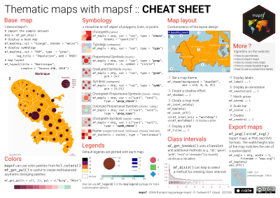
You can find more detailed examples on the “Get
Started” section of
the package website and you can
also download its cheat
sheet.

The mapsf.gui package
provides a Shiny interface for creating thematic maps using mapsf.
Users of the application can build thematic maps interactively and
automatically generate the corresponding R code to reproduce the map
identically.
One can contribute to the package through pull
requests and report issues or
ask questions here. See the
CONTRIBUTING.md
file for detailed instructions on how to contribute.
This project uses conventional
commits and
semantic versioning.